Health & Fitness
Bitter Cold, Strong Winds and Snow To Impact Area
This Winter's first real shot at bitter cold temperatures have fallen upon us.
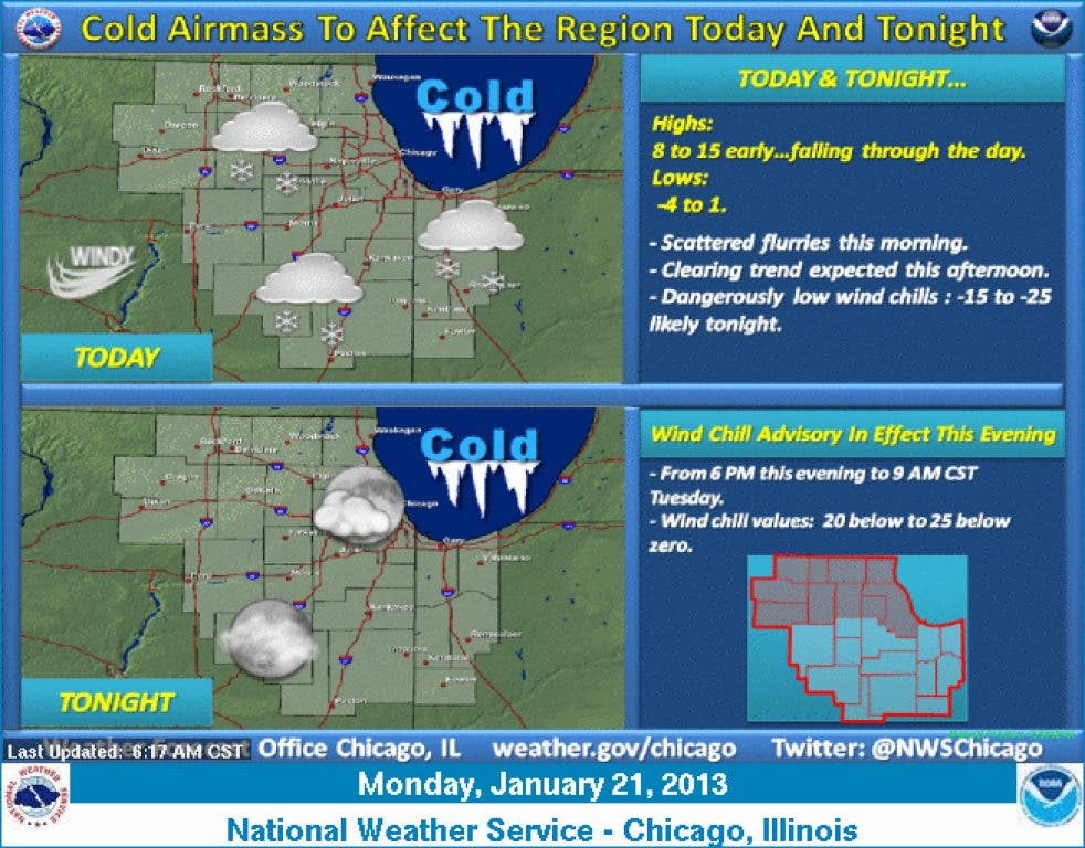
This Winter's first real shot at bitter cold temperatures have fallen upon us. Saturday's temperatures were near the 50 degree mark before a powerful Arctic cold front swept down out of the Canadian Prairies ending our lottery ticket of a warmer than normal Winter....at least for the time being. With this FroPa (frontal passage) temperatures dropped 15 degrees in an hour and winds gusted to 71 mph over Lake Michigan. While Midway and O'Hare both registered gusts to near 50 mph. Some light snow/flurries impacted the region this morning generally along and south of I 80 with temperatures in the low teens.
Temperatures continue to free fall on this Martin Luther King Jr. day. Tonight will be the coldest night since February 10th, 2011 with many areas hovering at or just below zero degrees. We haven't seen a sub-zero temperature since the aforementioned date our second longest stretch in recorded history. The temperature itself is not the only story, there will be a brisk northwesterly wind dropping wind chill values to -25 degrees over the area. As a result the National Weather Service in Chicago has issued a wind chill advisory for the area until Tuesday morning. Tuesday will be another cold day, but a slight warming trend is on tap on Wednesday into Thursday.
The next few days will feature relative dry weather with no chance of snow. The next storm system of interest appears Thursday and could bring the areas first 1" inch snowfall of the season. Still a lot of uncertainty evolving, but it looks possible that the area could be in line for accumulating snowfall. Water content looks to be rather light meaning if the snow does fall it will be the light fluffy snow that generally piles up more quickly than the dense "wet" snow. I invite you all to like my Facebook weather page to stay completely on top of the weather in Northern Illinois and specifically the southern Chicago regions. https://www.facebook.com/pages/Northern-Illinois-Storm-Chaser-Forecastin...
Find out what's happening in Evergreen Parkwith free, real-time updates from Patch.
After this shot of true Winter, temperatures will climb back to more seasonal values with some models advertising highs climbing back toward 40 degrees in the next week.
More later this week.
Find out what's happening in Evergreen Parkwith free, real-time updates from Patch.
Danny